It’s big, it’s accurate, and it will help Gunnedah Shire face disasters like the floods of 2021-22.
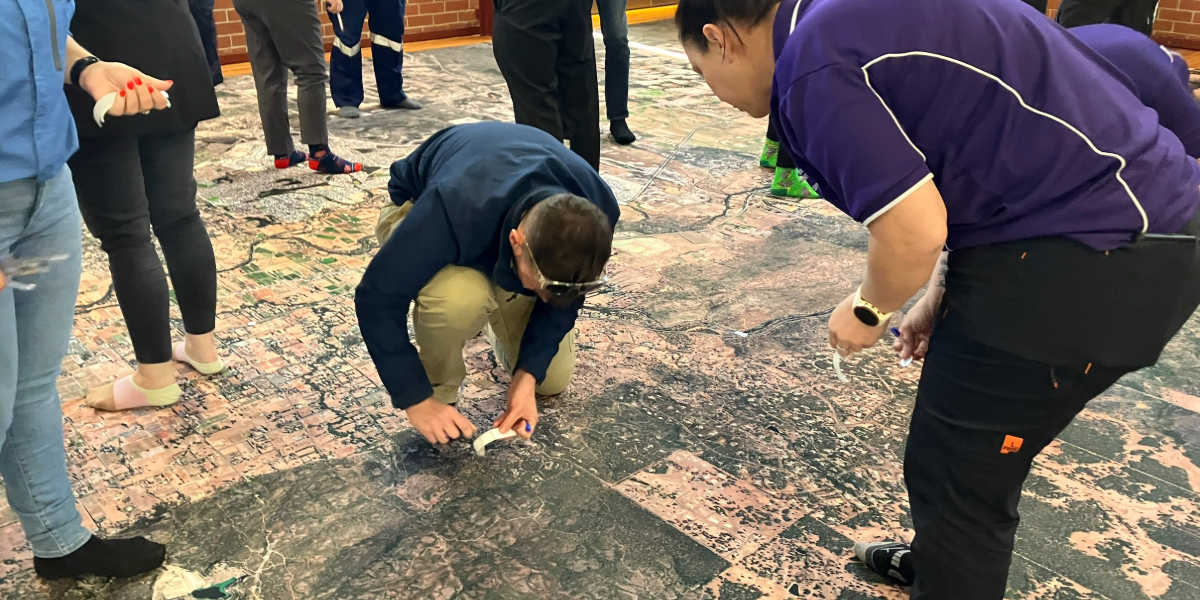
The Big Map – a 15m x 9m aerial photograph that allows people to actually walk across the Shire – is at the centre of a series of Disaster Relief Australia (DRA) sessions to be held in Gunnedah and Narrabri early November.
DRA Emergency Management Specialist and National Resilience Manager Adam Moss said the Big Map project brought together stakeholders and the community to take a bird’s eye view of flooding across the Shire.
“The Big Map is a connector,” he said. “It’s an interpretation tool that connects a community and enables people to work together to see the bigger picture and understand the potential risks and hazards they face in the area they live.”
DRA Resilience Manager Shari Bent said weather events were continuing to increase in severity and frequency.
“Communities now more than ever need to understand the possible risks and hazards ahead,” she said. “Walking the Big Map is a unique way to explore where you live and gain new perspective on these threats to your communities. Once communities understand these risks and hazards, they can work together to identify ways to mitigate better prepare for next time.”
Gunnedah Shire Council Community Recovery Officer Karen Grimm said the project was a step forward in working with stakeholders and the community to assist in future preparedness and recovery readiness planning and events.
“Local knowledge is critical in understanding and preparing for future events,” Ms Grimm said. “People who have lived and worked through previous disasters know exactly what effect they had and where.
“The Big Map sessions are a great, visual way to take our disaster readiness to the next level. Local community knowledge combines with stakeholder information, science and government and organisational expertise to work towards better ways forward.”
Gunnedah Shire Council Local Emergency Management Officer Wade Berryman said there would be two sessions in Gunnedah Shire, one on Friday, 1 November for key stakeholders, emergency services and local government representatives, and one on Saturday, 2 November for the community.
“Not only is this a great opportunity for the community, but the Friday event will be very important in bringing together the on-the-ground agencies,” Mr Berryman said.
“The session will help us to further identify areas at risk and provide an opportunity to talk about roles and responsibilities, assist in working towards practical steps to follow as events unfold, and find out where the gaps exist.
“When we are prepared and all agencies work together according to a well-considered plan, the outcomes for the community can be improved.”
Acting Chief Superintendent Matthew Kirby – Zone Commander NSW SES said the NSW SES was excited to be involved in the Big Map community events in Gunnedah and Narrabri.
“The NSW SES is pleased to be partnering with Disaster Relief Australia, the Minderoo Foundation, and Gunnedah and Narrabri Shire Councils to deliver the Big Map events in early November.
“During the flooding events of 2021 and 2022, both Gunnedah and Narrabri experienced significant flooding. Giving community members the opportunity to view their flood risk on a 15m by 9m aerial photograph and map allows for a far better understanding of the impact of flooding in and around their community, hopefully ensuring they are better prepared during future flooding events.
“The NSW SES is committed to continuing its flood preparation and response activities across the New England North West. Events like the Big Map, ensure we can continue to educate and equip communities with the skills and knowledge to identify and manage flooding hazards across the region.”
The Gunnedah Shire community Big Map event will be held from 9.30am to 3.30pm on Saturday, 2 November, 2024 at the PCYC in View Street. The event is free, but participants are asked to register at https://disasterreliefaus.org/what-we-do/community-resilience-plans/big-map/ or email resilience@disterreliefaus.org
A Narrabri Shire community Big Map event will be held from 9.30am to 3.30pm on Sunday, 3 November 2024 at the Main Auditorium, The Crossing Theatre, Narrabri. It is free and participants can register on the links above.
Don’t miss any of the important stories from around the region. Subscribe to our email list.