
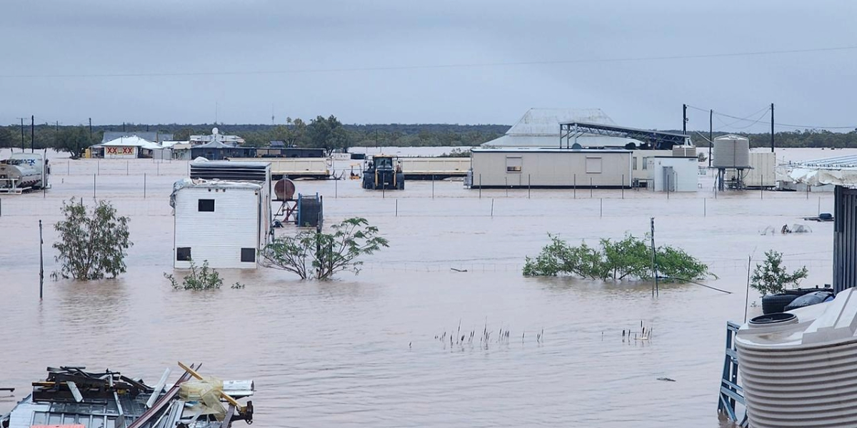
More flood warnings have communities across three states on high alert following days of heavy rain and, for some parts of Queensland, the worst flooding in 50 years.
The impacts of record-breaking rainfall will persist with enormous livestock losses expected as communities brace for more major flooding in the coming days.
More flood warnings have been issued after a deluge of wet weather lashed Queensland in some of the worst flooding in more than 50 years.
Floodwaters have cut roads and isolated communities after days of rain, forcing many in central and southwestern parts of the state to flee.
Graziers in western parts of the state are expected to lose a staggering number of livestock. Dozens of outback Queenslanders were flown to safety on Saturday as floodwaters took over their towns and properties.
The population of Adavale – a southwestern community of about 30 people – was flown out by helicopter to nearby Quilpie while those in nearby Jundah continue to evacuate.
Central Queensland’s Stonehenge and Windorah have also been hit hard after some areas recorded almost double their average yearly rainfall, triggering flooding not seen since 1974.
Locally, flood warnings are in place for Gwydir, Peel and Namoi rivers. Flash flooding has been experienced in parts of Narrabri and Gunnedah with a plea from the NSW SES not to enter flood waters. There has also been flooding on the Peel River at Tamworth, which peaked around midnight last night and is now dropping.
As at Sunday morning (30/3):
- The Gwydir River at Gravesend Road Bridge was at 6.71 metres and steady, above the minor flood level (6.10 metres). The Gwydir River at Gravesend Road Bridge is likely to peak near 8.00 metres late Sunday morning, with minor flooding. Further rises are possible.
- The Gwydir River at Pallamallawa was at 1.13 metres and steady, below the minor flood level (6.00 metres). The Gwydir River at Pallamallawa is likely to reach the minor flood level (6.00 metres) around Sunday evening. Further rises are possible.
- The Gwydir River at Yarraman Bridge was at 0.95 metres and steady, below the minor flood level (4.00 metres). The Gwydir River at Yarraman Bridge is likely to reach the minor flood level (4.00 metres) overnight Sunday into Monday. Further rises are possible.
- The Namoi River at Gunnedah is currently at 0.81 metres and rising, slowly, below the minor flood level (7.30 m). The Namoi River at Gunnedah may reach the minor flood level (7.30 m) overnight Sunday into Monday. Further rises are possible.
- The Namoi River at Boggabri is currently at 6.70 metres and rising, below the minor flood level (7.00 m). The Namoi River at Boggabri is likely to exceed the minor flood level (7.00 m) around 07:00 am Sunday. The river level may reach around 7.50 metres Sunday afternoon, with minor flooding. Further rises are possible.
- The Narrabri Creek at Narrabri peaked at 4.39 metres around 02:00 am Sunday 30 morning and is currently at 4.33 metres and steady, below the minor flood level (4.90 metres). The Narrabri Creek at Narrabri is likely to remain below the minor flood level (4.90 m) for the remainder of Sunday. However, renewed rises are expected over the coming days as floodwaters travel downstream.
- The Namoi River at Wee Waa (Glencoe) is currently at 5.22 metres and rising, just below the minor flood level (5.30 m). The Namoi River at Wee Waa (Glencoe) is expected to exceed the minor flood level (5.30 m) around 06:00 am Sunday. The river level is likely to reach around 6.00 metres Sunday afternoon, with minor flooding. Further rises are possible.
- The Namoi River at Bugilbone is currently at 1.98 metres and rising, below the minor flood level (4.90 m). The Namoi River at Bugilbone may reach the minor flood level (4.90 m) from Sunday evening. Further rises are possible.
The steady rain across the region has helped those areas that missed out on the forecast rains from Tropical Cyclone Alfred that never eventuated. The nearly five inches at Narrabri and 50ml at Moree over the past week is particularly welcome after only getting 7ml from the Alfred storm system, and bodes well for the winter crops.
Town 7 Day Rainfall Total to 9am Saturday 29/3/2025 Deepwater 26ml Armidale 35ml Glen Innes 42ml Guyra 43ml Inverell 47ml Barraba 66ml Tenterfield 54ml Gunnedah 79ml Moree 50ml Mungindi 92ml Narrabri 118ml Tamworth 56ml Quirindi 66ml Warialda 53ml
Prime Minister Anthony Albanese announced more than $2 million in disaster funding for the region, while Opposition Leader Peter Dutton said he supported calling out the Australian Defence Force to assist if required.
Nationals leader David Littleproud called for large-scale federal support and said helicopters were “buzzing around like bees”, dropping fodder onto properties.
“The stock losses here and right up towards Winton are going to be enormous,” he told the ABC from Quilpie.
Personal hardship assistance has been activated, with concessional loans and freight subsidies to help primary producers in a string of western Queensland communities.
Queensland Premier David Crisafulli said the flooding would inundate hundreds of thousands of hectares.
“The peak hasn’t yet hit Quilpie which means it will be a few days before places like Thargomindah and Hungerford and Cunnamulla experience the worst of the water,” he said on Saturday afternoon.
The premier said floodwaters had already destroyed thousands of kilometres of livestock fencing and authorities were prioritising fodder drops to minimise livestock losses.
“You’ve got somewhere in the order of a million head of cattle, a million sheep who are impacted at the moment and we could see stock losses into the hundreds of thousands,” he said.
The Bureau of Meteorology said major, significant flooding was continuing across inland parts of Queensland with rain and storms sweeping across eastern parts of the state into NSW. A number of severe weather warnings have been issued for NSW with minor flooding expected.
“We’ll see heavy rainfall from Saturday afternoon and into the evening, which could produce flash flooding with six hourly totals up to 70mm possible, and high isolated falls above that,” senior meteorologist Jonathan How said.
The hazardous conditions are set to persist into Monday and possibly also into Tuesday.
Communities in Western Australia’s north are also on high alert for the risk of flooding as ex-tropical cyclone Diane moves inland after crossing the coast on Saturday morning.
Don’t miss any of the important stories from around the region. Subscribe to our email list.